Hiking in Greece: Best Trails Guide — Samaria Gorge, Mt Olympus, Vikos, Menalon
Book an experience
Book this activity
These are the top-rated activities for this area — book ahead to lock in your preferred date.
Greece’s reputation is overwhelmingly maritime — islands, beaches, ancient ruins on clifftops. The hiking is a different story. The mainland has major mountain ranges, deep limestone gorges, and a long-distance trail (the E4, which runs 2,200km from Spain to Cyprus, crossing Greece from the Albanian border to Crete) that links some of the most spectacular walking in the Mediterranean.
This guide covers the four trails most worth planning a trip around — plus practical advice for each.
Samaria Gorge, Crete
Distance: 16km (one-way, north to south)
Ascent/Descent: 1,200m descent
Duration: 4–7 hours depending on pace
Difficulty: Moderate (the descent is long; the terrain is rough underfoot in places)
Season: Open approximately early May to late October (exact dates vary — check with the White Mountains National Park authority, sfakia.com or the gorge entry desk before planning)
Entry fee: €5 adult (as of 2026)
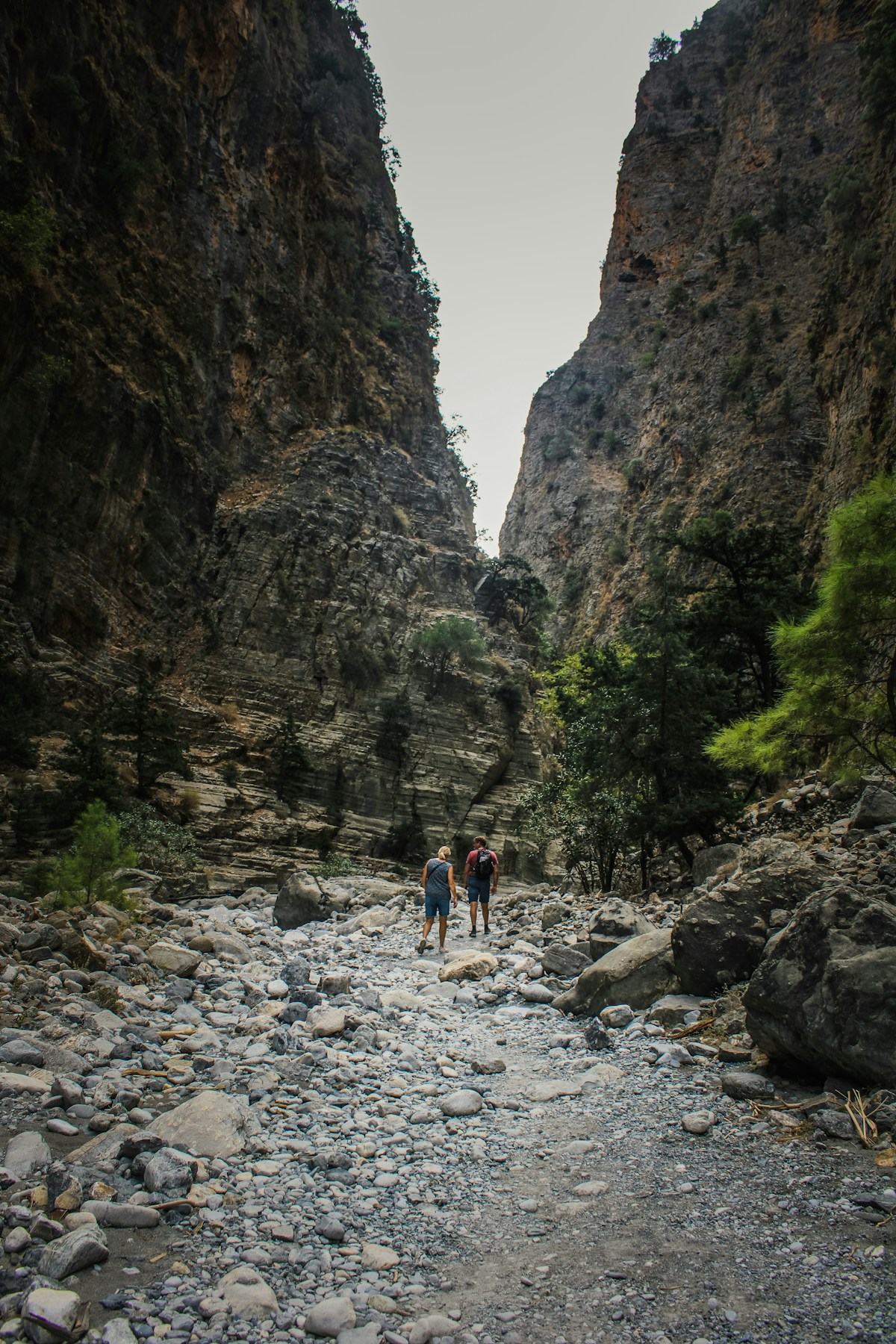
Samaria Gorge is the longest gorge in Europe and one of the most walked trails in Greece. You descend from the Omalos plateau (1,230m) through a 16km limestone canyon — the walls narrow to 3m at the famous Iron Gates section — to the small coastal village of Agia Roumeli at sea level.
The hike: The descent from the northern entrance (Xyloskalo) is steep for the first 4km, then levels out through pine and cypress forest. At kilometre 12, the gorge narrows dramatically to the Iron Gates section — the walls rise to 600m and are 3–4m apart at the base. Agia Roumeli at the end has tavernas, a beach, and cold water.
Getting there and back: The standard approach is a morning bus from Chania (departures from 6–8:30am, approx. €3 each way). You exit at Agia Roumeli, which is accessible only by foot or boat — take a ferry back to Hora Sfakion (approximately 30 minutes, €10 as of 2026), then a bus back to Chania.
Practical notes:
- Start early — the gorge hits full sun by 10am and the temperature inside rises fast in summer
- Wear proper walking shoes with ankle support; the rocky terrain is brutal on trainers
- Carry 2–3 litres of water; springs inside the gorge provide potable water until mid-summer (check at entry desk)
- In July and August, the gorge hosts 3,000–4,000 visitors per day; the first bus crowds arrive around 9am. The first morning entry is the best experience
Guided options: Organised tours from Chania include transport and ferry return; approximately €35–50 per person (as of 2026). Available through GetYourGuide and local operators.
Mount Olympus, Central Macedonia
Main summit (Mytikas): 2,917m — the highest point in Greece
Standard 2-day route: Prionia trailhead (1,100m) → Refuge A (2,100m) → Skala/Mytikas (2,866m/2,917m)
Distance (full circuit): approximately 28km
Difficulty: Strenuous; Mytikas summit involves Grade 2 scrambling and exposed ridges
Season: Mid-June to late October for summit routes; snow can persist on the north face through June
Entry: Free (within the Mt Olympus National Park, the oldest national park in Greece, established 1938)
Mount Olympus is Greece’s mythological summit — the home of the twelve Olympian gods. The mountain is also a serious alpine environment: at 2,917m, Mytikas is the highest point in Greece and frequently has summit conditions (wind, cloud, cold) even in August.
The standard route:
Day 1: Drive or taxi to Prionia trailhead (from Litohoro, approximately 18km on a forest road). Trek 6km through beech and fir forest to Refuge A (also called Spilios Agapitos Refuge, at 2,100m). The hike takes 3–4 hours. The refuge is a full mountain hut with beds, meals, and equipment available — book well in advance for July–August (olympusrefuge.gr, approximately €20–25/bed as of 2026).
Day 2: Pre-dawn departure (3–4am) for the summit assault. The ridge walk to the Skala plateau (2,866m) takes 2–2.5 hours. From Skala, the Mytikas summit involves 30–40 minutes of exposed scrambling on loose rock — the final approach (the “Kakoskala” or “bad steps”) is steep with no fixed protection. In summer conditions, physically fit hikers can manage it with care; the risk is exposure and loose rock.
The neighbouring summit Skolio (2,912m) is accessible without scrambling and offers comparable views.
Alternative: A day hike from Litohoro to Prionia and up to the plateau takes 5–6 hours each way and is rewarding without the summit ambition.
Practical notes:
- Check weather on mountain-forecast.com specific to Mt Olympus — summit winds regularly exceed 40km/h even in summer
- A guide is strongly recommended for first-time Mytikas ascents; licensed mountain guides in Litohoro include Kostas Zolotas and the Litohoro EOS (mountain rescue club) guide network
- The village of Litohoro at the mountain base has good accommodation and tavernas — a convenient overnight before the ascent
Vikos Gorge, Epirus
Distance (standard traverse): 12km (one-way, Monodendri to Vikos or Papigo villages)
Ascent/Descent: 900m descent
Duration: 4–6 hours
Difficulty: Moderate
Season: Year-round; best April–June and September–October
The Vikos Gorge in the Zagori region of Epirus is listed in the Guinness Book of Records as the world’s deepest gorge relative to its width. The walls rise to 900m above the Voidomatis River at the canyon floor.
The hike: The standard route begins at the village of Monodendri (stone houses, a monastery perched at the gorge rim, remarkable views) and descends into the gorge via a stone-stepped kalderimi (traditional mule path). The floor of the gorge follows the Voidomatis River — clear enough to drink in the upper sections, and cold from snowmelt through June. The route exits at either Vikos village or continues to the twin Papigo villages (Megalo and Mikro Papigo).
The Zagori region: The gorge is the centrepiece but not the whole picture. The Zagori consists of 46 villages — the Zagorochoria — connected by stone bridges and kalderimi paths and largely preserved from 19th-century prosperity. The villages of Aristi, Monodendri, Kipi (with its arched bridges), and the Papigos are among the best-preserved stone village architecture in Greece.
Practical notes:
- Accommodation in Zagori is excellent — small stone guesthouses in Megalo Papigo, Aristi, and Monodendri. Book ahead in May and September (peak season for Greeks and hikers)
- Getting to Zagori requires a car or joining a tour from Ioannina (40km away)
- The gorge is subject to flash flooding after heavy rain — do not walk the floor in or after significant rainfall
Menalon Trail, Arcadia (Peloponnese)
Total distance: 75km (divided into 8 segments of 7–13km each)
Best segment: Stemnitsa to Dimitsana (15km, 4–5 hours)
Difficulty: Easy to moderate (most segments are forest paths and old mule tracks)
Season: Year-round; spectacular in spring (wildflowers) and autumn (beech colours)
The Menalon Trail is a long-distance hiking route through the Menalon mountain range in Arcadia — the rugged heart of the Peloponnese. It passes through medieval Byzantine villages, chestnut and oak forests, and watermills along the Lousios Gorge.
The Lousios Gorge section (segments 3–4, from Stemnitsa to Dimitsana via the Prodromos Monastery) is the highlight: a river gorge with Byzantine monasteries carved into the cliff face, ancient plane trees, and the sound of water mills on the Lousios River (which Greek mythology names as the river where Zeus was bathed as an infant).
Key villages: Stemnitsa and Dimitsana are the most significant — both have Byzantine churches, small folklore museums, and good tavernas. Dimitsana has a working watermill and an Ecclesiastical Museum with an 11th-century manuscript collection.
Practical notes:
- Segments are well-waymarked with yellow signs
- Accommodation is available in Stemnitsa, Dimitsana, Vytina, and Karytaina
- Getting here requires a car from Tripoli or Kalamata; no public transport on the trail route
- Combined with the ruins at ancient Gortys (2km from the Lousios gorge floor) and the archaeological site at Mantineia, the Arcadia region justifies 2–3 days
Other Routes Worth Knowing
Pelion Peninsula (Thessaly): The peninsula has a network of old kalderimi paths connecting the traditional villages of Zagora, Tsangarada, and Milies through chestnut forest and overlooking the Pagasitic Gulf. Day walks or multi-day self-guided routes. Accessible from Volos.
Taygetos, Mani (Peloponnese): The spine of the Mani peninsula, rising to 2,407m. A strenuous 2-day ascent from Kalamata or Sparta — technically challenging in the upper sections but with extraordinary views over both coasts of the Peloponnese.
Crete: E4 trail sections: The Cretan section of the E4 long-distance trail runs along the south coast and through the White Mountains. Self-sufficient multi-day trekking with coastal camping.
What to Pack
- Footwear: Ankle-support walking boots for Samaria and Vikos; approach shoes for Olympus summit. Trainers are not adequate for any of the gorge routes.
- Water: Minimum 2 litres regardless of season; more in summer
- Sun protection: Essential at altitude and on Crete — the Samaria Gorge has limited shade in mid-sections
- Layers: Mountain weather in Greece changes quickly. A wind layer and light insulation are necessary above 1,500m regardless of season
- Navigation: Download the relevant map section on maps.me or purchase 1:25,000 maps from Anavasi (the best specialist Greek cartographer, anavasi.gr)
Book guided hiking and trekking experiences in Greece with GetYourGuide.
See Also
- Ioannina Travel Guide — the base for Vikos Gorge and Zagori hikes
- Meteora Travel Guide — monastic plateau with excellent hiking between the rocks
- Crete Island Guide — Samaria Gorge context and the island’s trail network
- Greece Car Rental Guide — most trailheads require a car to reach
- Greece Packing List — hiking-specific kit for Greek trails
- Best Time to Visit Greece — when mountain trails are accessible vs snowbound
Frequently Asked Questions
- What is the most famous hike in Greece?
- The Samaria Gorge on Crete is Greece's most-walked trail — 16km through the longest gorge in Europe, descending 1,200m through a spectacular limestone canyon to the coast. Open May to October; approximately 5–7 hours for most walkers.
- Can non-climbers reach the summit of Mt Olympus?
- The main summit (Mytikas, 2,917m) requires basic scrambling and exposure to vertiginous ridges — not for beginners. The neighbouring peak Skala (2,866m) is more accessible as a scramble but still strenuous. Most day-hikers reach the Skala plateau; the summit assault involves an overnight at Refuge A (at 2,100m). A guide is recommended for first ascents.
- When is the best time to hike in Greece?
- Late April to June and September to October are the best months — cool temperatures, spring flowers (late April–May), and uncrowded trails. July and August are hot and the Samaria Gorge is extremely crowded. Mt Olympus is hikeable from June to October; higher routes are snow-covered in winter. Vikos and Menalon are good year-round except in extreme winter snow.
- Do I need a guide for Greece's main hikes?
- Samaria Gorge is well-marked and can be done independently. Vikos and Menalon are waymarked with the E4 trail markers. Mt Olympus is more complex — a guide is strongly recommended for the summit and useful for navigation on the higher routes. Licensed guides can be arranged through the Litohoro mountain rescue association or via GetYourGuide.
Car Hire
Hire a Car for Greece
A car is the best way to reach Greece's islands, coastal roads, and ancient sites. GetRentacar compares suppliers to find the best rate — with a 90-day price lock.
We may earn a small commission — at no extra cost to you.
Ready to explore?
Browse hundreds of tours and activities. Book securely with free cancellation on most options.
Browse on GetYourGuide →We may earn a small commission — at no extra cost to you.